How it works
Rapid Mapping in 30 seconds
When a disaster strikes, the Copernicus Emergency Management Service is
activated. Each activation gets a code (EMSR762) and one or more
areas of interest (AOI). For each AOI analysts publish products: a
first map, then monitoring updates. Each product holds vector
layers; the one that says where the event actually was is
observedEventA.
flowchart LR
    D["Disaster"] --> A["Activation<br/>EMSR762"]
    A --> AOI1["AOI01 Brisighella"]
    A --> AOI2["AOI02 Idice"]
    AOI1 --> P1["DEL_PRODUCT<br/>first delineation"]
    AOI1 --> P2["DEL_MONIT01<br/>monitoring update"]
    P1 --> L1["observedEventA<br/>(flooded area)"]
    P1 --> L2["floodDepthA, …"]
    L1 -->|copernicus-ems| G[".geojson on your disk"]
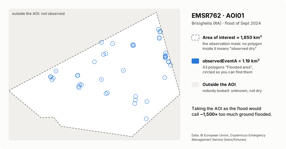
The observation mask: why the AOI is not the flood
| Where | What it means | In the library |
|---|---|---|
inside an observedEventA polygon |
observed flooded | ProductEvents.features |
| inside the AOI, no polygon | observed dry | Product.aoi_extent_wkt minus the features |
| outside the AOI | not observed: unknown | — |
A model that predicted a flood outside every AOI has not raised a false alarm: nobody looked. Inside the AOI and outside the polygons, it has.
Which time to use
An activation has an event_time; each product has an observed_time, the
earliest satellite image it was made from. Use observed_time to say
when the water was seen.
timeline
    title EMSR664, AOI01 (May 2023)
    16 May : event_time (activation)
    17 May 16:56 : DEL_PRODUCT observed, 1153 polygons
    18 May 16:55 : DEL_MONIT01 observed, 462 polygons
    22 May 10:27 : GRA_PRODUCT observed, 92 polygons
What fetch_layer decides
flowchart TD
    start(["fetch_layer(client, product, kind)"]) --> c0{"product has<br/>a layer of that kind?"}
    c0 -- no --> rn(["return None"])
    c0 -- yes --> c1{".geojson already<br/>in the directory?"}
    c1 -- yes --> r1(["read it from disk<br/>no network"])
    c1 -- no --> g["GET the layer's json URL"]
    g --> v{"valid<br/>FeatureCollection?"}
    v -- no --> e(["raise EmsError<br/>nothing written"])
    v -- yes --> w["write .part, rename to .geojson"]
    w --> r2(["return the collection"])
A layer's file name carries its version (…_observedEventA_v2), so a file
in the cache is never stale. The activation list and details are not
cached: new monitoring products appear in them.
The building blocks
flowchart LR
    subgraph yours["Your code"]
        H["httpx.AsyncClient<br/>(optional)"]
    end
    subgraph lib["copernicus_ems"]
        direction TB
        RM["client.py<br/>RapidMapping · RetryTransport · fetch_*"]
        CA["catalogue.py<br/>parse_activations · parse_detail"]
        EV["events.py<br/>parse_layer · select_features"]
    end
    H -.-> RM
    RM --> CA
    RM --> EV
The traps we already fell into
| You try | What actually happens | What copernicus-ems does |
|---|---|---|
the product package (_products.zip) |
~100 MB of zips of zips, and 403 for some activations | reads the open GeoJSON layers |
| the AOI as the flooded area | ~1,500× too large on EMSR762 AOI01 | reads observedEventA, keeps the AOI as the mask |
category Flood |
many Italian floods are Storm |
filters features on event_type |
| every feature of a flood activation | the landslides of the same rain are in it | keeps 5-Flood by default |
event_time as the observation time |
it is when the event started | Product.observed_time |
countries from list and detail |
strings in one, {"name": …} in the other |
normalises both |
| an older layer version | the API lists every version | keeps the latest of each kind |
| the dashboard API, many times in a row | 502 now and then | RapidMapping retries with backoff |
Limits
- The public API lists activations from 2023; older ones live on the legacy site, with no documented API.
- Satellite delineation is a lower bound: short urban floods and water under canopy may not show.
- Activations are not only European: filter on
country.